Flood planning group seeking feedback from public

 From Enterprise Staff
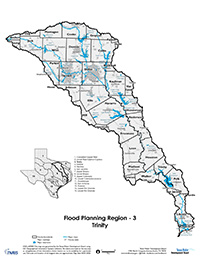
A preliminary interactive floodplain webmap of the Trinity River Basin has been created from information the Trinity Regional Flood Planning Group (Trinity RFPG) received from cities, counties, entities with flood control responsibilities, property owners and other entities or individuals. The Trinity RFPG is asking the public to review and identify any potential gaps or inaccuracies in the depiction of flood-prone areas within the newly created map.
The feedback will be used to ensure a more accurate, up-to-date floodplain map for the Trinity River Basin. The interactive floodplain map will be available until March 25.
The interactive floodplain webmap is part of the Trinity RFPG’s important work to develop the first-ever Trinity Regional Flood Plan for the 38-county Trinity River Basin. This past summer, the Trinity RFPG began its flood risk data collection. The planning group requested various technical, flood-related data from organizations with flood-related responsibilities across the region, to identify existing and future flood risks in local areas. The collected data was used to produce this interactive floodplain map.
The floodplain webmap can be found on the public comment page of the Trinity RFPG website which is www.trinityrfpg.org. Members of the public are asked to review the map and add comments or points wherever there are potential errors in the floodplain map within their community or neighborhood. Submissions will be important when incorporating known issues into the GIS layers of the map, as appropriate. Additionally, the input will be helpful as the Trinity RFPG continues to develop recommended studies, projects and strategies to mitigate and manage flooding issues throughout the Trinity River Basin.
Tips for using the interactive webmap:
Stakeholders can search for specific areas by entering an address or place name in the search bar in the upper left corner of the map. Then, using the add a comment tool in the lower-left corner, they can add pins with comments to help identify areas of flooding concerns that are not captured accurately in the map.
Members of the public should use the public comment pin to mark areas of concern. Also, participants are asked to include their contact information (email address) with any added comments. Contact information will be used to communicate with individuals if questions or clarification are needed about the local flooding issue.
Related Articles
About the Trinity Regional Flood Planning Group
and the Flood Planning Process Statewide
The Trinity RFPG is among 15 regional flood planning groups designated in April 2020 by the Texas Water Development Board (TWDB) as a result of Senate Bill 8 from the 86th Texas Legislature, which established a groundbreaking, new regional and state flood planning process for the state. At the same time, the Texas Legislature also created a new flood financial assistance fund and charged the TWDB with administering the fund. The Flood Infrastructure Fund, approved by Texas voters in November 2019, will be used to finance flood-related projects.
The Trinity RFPG is responsible for creating its first Regional Flood Plan by January 10, 2023. This plan will then become part of Texas’ first-ever State Flood Plan by September 1, 2024. After this first round of flood planning, each of the regional flood planning groups will update their plans every five years.
The initial members of the Trinity RFPG were designated by the TWDB. The Planning Group’s membership includes at least one voting member from each of the following interest categories: the public, counties, municipalities, industry, agriculture, environment, small business, electric-generating utilities, river authorities, water districts, water utilities and flood districts. In April 2021, the Trinity RFPG engaged a technical consultant team led by Halff Associates to support its planning effort.
The Trinity RFPG’s planning region (Trinity River Basin, or Region 3) has an estimated population of almost 8 million. It spans a nearly 18,000-square-mile, 38-county region from Cooke County in the north to Chambers County on the Gulf Coast.
For more information, visit the Trinity RFPG website at www.trinityrfpg.org, follow the group on Twitter https://twitter.com/TrinityRFPG or email the group via This email address is being protected from spambots. You need JavaScript enabled to view it..
You are a guest
or post as a guest
Be the first to comment.
